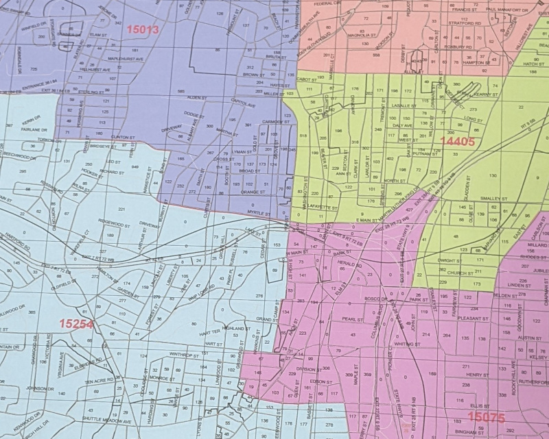
The city Redistricting Commission tentatively chose a plan for City Council districts that appears to not represent the city’s diversity.
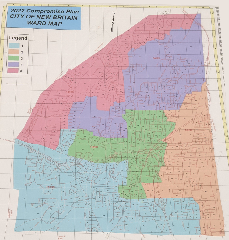
The map tentatively chosen for Council districts would, notably, eliminate the city’s current Ward 3, dividing it between four of the five other wards. The current Ward 3 has the largest proportion of people of color.
The Council districting map, which is called the Commission’s “Map 2” or “Compromise Map 2” is to be the tentative map about which the Commission will seek comments from the public in a hearing on March 16, 2022.
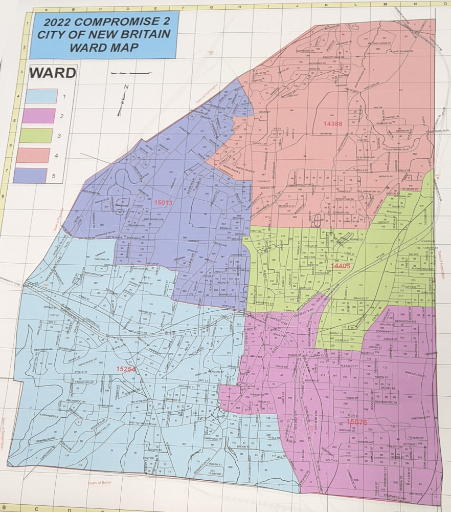
The “Map 2” plan that the Commission voted to present is a modification to a map submitted to the Commission earlier by Republican Registrar of Voters Peter Gostin (R).
But the choice of Map 2 by the Commission came after vigorous debate between members who favored Map 2 and others who preferred a map that the Commission called its “Map 1” or “Compromise Map 1”. That map, also a variation of an earlier proposal, would leave the current Ward 3 largely intact.
The six member commission held three votes. In one, Map 1 was not selected after a 3 to 3 tie vote. Map 2 was then also not selected, by a 3 to 3 tie. The Commission members finally agreed to present Map 2 as the Commission’s tentative map, while also taking public comment on Map 1.
According to data from the United States Census Bureau, the percentages of communities of color (including Latinos, African Americans and Asian Americans) among New Britain’s population has grown from 52% in the 2010 census to nearly 63% in the 2020 census.
That increase to 60% of the population means that 60% of the city’s five Council districts could be solid majorities of communities of color. An analysis done by New Britain Progressive volunteer efforts, using the web service, Dave’s Redistricting, showed that is possible.
However neither of the Commission’s two proposals appear likely to provide districts allowing communities of color the clear decisive vote in the three out of the five, 60%, of the districts that is commensurate with their population in the city.
The data from Dave’s Redistricting appears to show that 57.47% of New Britain’s voting age population are members of communities of color, 38.77% are Latino and that 17.05% are Black.
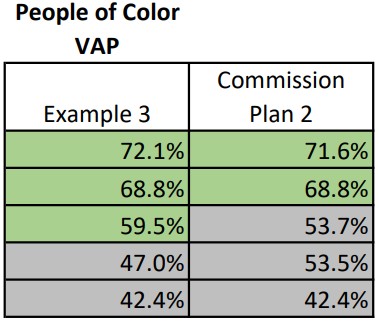
While the Commission’s “Map 2” proposal would appear to have four districts with a majority voting age population of communities of color, two of those four districts would be nearly 50% white voting age population. If white voter participation were higher in city elections in those districts, that would translate into 60% of the voting power in ward Council elections being controlled by white voters — the opposite of the fact that the population of the city is greater than 60% communities of color.
The opposite would appear true in the “Example 3” districting model, reported in the New Britain Progressive article, “Redistricting Can Help, Or Harm, City Council Diversity“. In “Example 3”, three of the five districts would appear to have voting age populations of nearly 60% or greater communities of color, increasing the chances that 60% of the voting power in Council Ward elections would be controlled by voters of color.
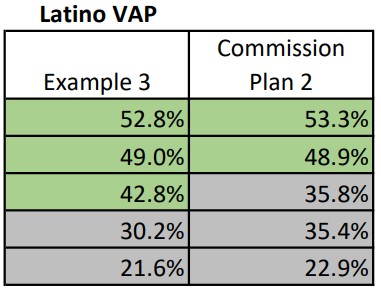
Similarly, in the Commission’s “Map 2” proposal, in three of the five districts, Latinos would appear to be considerably less than the 38.77% that they are of the whole New Britain voting age population. “Example 3” appears to appears to provide greater voting power to Latinos in particular, with Latino voting age populations of greater than 40% in three of the Council wards.
The data also appears to show that, “Example 3” would have two wards of about 20% African American voting age population, while the Commission’s “Map 2” would only have one, while Commission’s tentative map would have three districts with greater than 17% African American voting age population.
Like with Congressional, State Senate and State House of Representatives districts, the five districts on the New Britain City Council, commonly called “wards”, are reapportioned every ten years, following the national decennial census. Two thirds of New Britain’s fifteen member Council are elected, two each, from the five wards. Another five Council members are elected at-large. The reapportionment, also called redistricting, is done to ensure that each district represents approximately the same number of people.
The Commission’s responsibility is to report a draft map of Council districts for the Council to review and approve. If either the commission or Council miss deadlines provided for in the City Charter, the mayor then proposes a three-person commission, who then make the final decision on the district lines.
The Charter requires that each of the five Council wards,
(1) shall be of substantially equal population and otherwise consistent with all federal and state constitutional and statutory requirements; (2) to the extent possible consistent with the preceding, shall maintain the integrity of recognized neighborhood planning areas; (3) shall be geographically contiguous and compact; and (4) to the extent possible consistent with the preceding, shall be consistent with existing legislative districts.
“Federal and state constitutional and statutory requirements,” have long been understood to include compliance with the federal Voting Rights Act.
Once approved, the new City Council ward boundaries will remain in effect for ten years. Those districts will be in place for the 2023, 2025, 2027, 2029 and 2031 city elections.

